
4 August 2021: BLOG – Where do all the whales go?
The North Atlantic and the North Pacific abounds in whales, but for most of them, we know very little about their migration patterns and wintering grounds. The fast-moving rorquals (the fin, sei, Bryde’s, blue and minke whales) and large dolphin species such as pilot whales, are among those with mysterious migratory patterns. These species are abundant and of great importance to both ecosystems and coastal communities. However, scientists still do not know exactly where they go in winter, nor whether there are separate stocks with separate migrations, although several plausible stock structure hypotheses have been developed.
In a new collaborative project (MINTAG), funded by the Member Countries of NAMMCO, the Fisheries Agency of Japan, and their associated national research institutes, scientists will collaborate on developing new satellite tag technology for tracking the movements of these poorly understood whales.
Find out more on the website: www.mintag-project.com
Satellite telemetry
Satellite telemetry allows researchers to track the movement of an animal by using orbiting satellites that detect signals emitted from a transmitter attached to the animal. It is a widely used technology for tracking everything from sea turtles to birds and mammals. It has also been used a lot on marine mammals, including some groups of larger whales, such as those that are easier to approach like the humpback and bowhead whales.
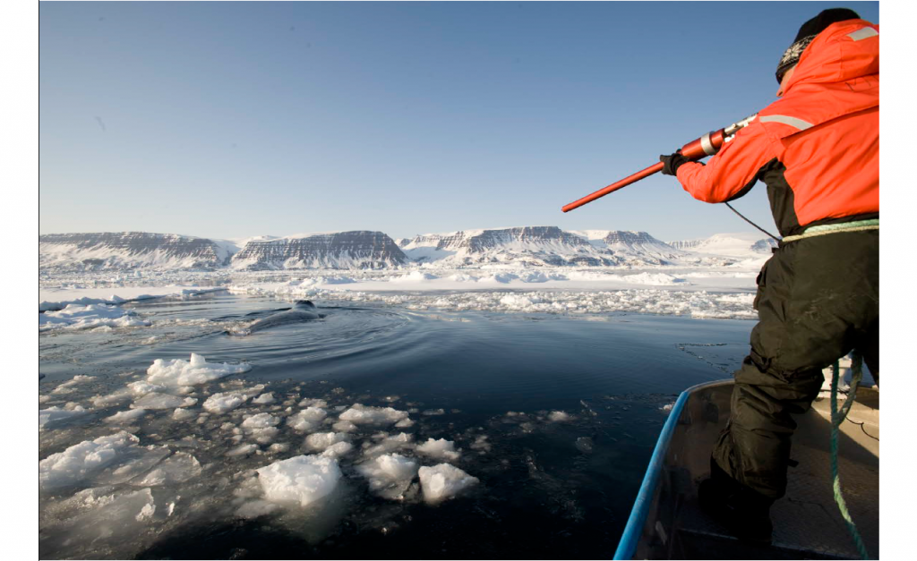
The large fast-swimming rorquals are typically too big to be captured alive and too skittish to be approached at close distance. So far, it has been difficult to successfully deploy satellite transmitter tags from a long-distance on these species. The goal of the MINTAG tag project is to develop new satellite telemetry tags and optimise the deployment methods to allow for the collection of year-round positions for these species.
In order to tag these whales, it is necessary to develop new satellite transmitters that are small and can be shot into the skin and blubber at distances over 20 m. This is often the closest that a well-trained whale-tagger can get to these whales. The whales show the back of their body for only a few seconds before the next dive, so a projectile tag needs to fly in a fairly straight line over distances up to 30 m.
The MINTAG project
The MINTAG project will work with a manufacturer to make miniaturised tags that meet the specifications of long-range deployment. The intention is to try and develop two sizes of tags. One will be for minke whales that is small enough to also be used on pilot whales. The second will be a slightly bigger tag for use on fin, Bryde’s and sei whales. A testing phase will follow prototype development to ensure that the tags perform as planned, both in terms of ballistic performance and longevity of the transmitter and battery unit.
Following successful tag development, the plan is to deploy 250 tags on the target species across the North Atlantic and North Pacific. A standard protocol for the tagging will be used. This is to ensure that data from different tagging situations can be compared to identify the most effective method. The large number of deployments will allow the team to learn about the functioning and reliability of the tags under different circumstances and for different target species. At the same time as helping to optimise the tagging method, this large series of deployments will also generate a wealth of new information about where the whales go. Quantity is important both when testing tags and trying to learn something new about whale movement patterns!
Once the successful development of the new tag has been confirmed through widespread testing, it will be made commercially available for research groups worldwide. It could also be applied to other species.
The importance of this new tool for management
The overarching ambition of the MINTAG project is to create a new satellite tracking tool that can generate data to improve the management and conservation of these whale species and the marine ecosystems.
Knowledge of where whales go provides important information for management. For example, understanding population structure and mixing is crucial for understanding the status of the species and determining what constitutes a sustainable harvest for communities utilising marine mammals. Tag-based research can also provide information on key breeding, feeding and transit areas, which can help inform best protective measures, when needed.
From an ecosystem perspective, tracking of whales can be a highly cost-efficient way of locating hot-spots of prey abundance in the open ocean. Marine production can be fluctuate a lot, both spatially and temporally. This means it can be difficult to locate productive spots in real-time, let alone understand the background for the fluctuations. Top predators like whales, however, know where the prey is and can therefore act as indicators. Tracking the whales will help to build an understanding of the oceanographic shifts frequently experienced in these years where ocean warming in the North Atlantic and North Pacific is ubiquitous.
An exciting new project
This is a dream project for cetacean tagging experts who have longed for the necessary funding to develop these smaller types of tags and to be able to systematically test their performance and deployment optimisation. It is also a wonderful opportunity for collaboration between cetacean scientists across the North Atlantic and North Pacific.
Today the project was officially launched with the first meeting of the steering group. Updates on the progress of the project will be provided on NAMMCO’s website where tracks of whales will eventually also be displayed. As project leader, I look forward to leading the MINTAG team in this collaborative endeavour over the next 5 years. Special thanks to NAMMCO Member Countries, the NAMMCO Secretariat and Japan for making this project possible and we look forward to sharing our progress and results in the years to come.
Prof. Mads Peter Heide-Jørgensen, Project Leader, MINTAG Project